Article Text

Abstract
Objectives There is previously reported a large variety of criterion measures and reference systems applied to validate position tracking systems in sports. This study aims to investigate the effect of different criterion measures and reference systems on the outcome of accuracy assessments of tracking systems in sports.
Methods Data from a commercially available standalone global navigation satellite system (GNSS) were compared with two different reference systems: a high-end differential GNSS and a tape measure. Differences in accuracy outcomes of position (static and dynamic), distance and speed (mean and instantaneous) were investigated in team sport imitation courses.
Results The mean horizontal position error was larger when athletes were in motion (dynamic position; 1.53±0.82 m) compared with static measurements (1.10±0.60 m). Measured distances of the courses were markedly different (+6% to −17%) between the two reference systems, causing differences in error. Differences in error were also found between mean speed and instantaneous speed (0.10 vs 0.28 m). Errors in mean speed were highly affected by the time over which speed was averaged.
Conclusion Choice of criterion measure and reference system has a substantial impact on the accuracy assessments of tracking systems. Specifically, assessing static position is not a substitute for dynamic position, and mean speed is not a substitute for instantaneous speed. Therefore, the outcomes of validation studies should always be interpreted in light of the reference methods that were used.
- Validity
- Assessing physiological demands of physical activity
- Exercise testing
- Method
- Speed
Data availability statement
Data are available upon reasonable request.
This is an open access article distributed in accordance with the Creative Commons Attribution Non Commercial (CC BY-NC 4.0) license, which permits others to distribute, remix, adapt, build upon this work non-commercially, and license their derivative works on different terms, provided the original work is properly cited, appropriate credit is given, any changes made indicated, and the use is non-commercial. See: http://creativecommons.org/licenses/by-nc/4.0/.
Statistics from Altmetric.com
WHAT IS ALREADY KNOWN ON THIS TOPIC
The use of position-based athlete tracking systems is exponentially increasing.
In the literature there is a large variety of criterion measures and reference systems used to investigate the accuracy of position tracking systems in sports.
WHAT THIS STUDY ADDS
This study shows that choice of criterion measure and reference system has a substantial impact on the outcome of accuracy assessments for position, distance and speed.
This study highlights the importance of an appropriate reference system in accuracy testing for position tracking systems.
HOW THIS STUDY MIGHT AFFECT RESEARCH, PRACTICE OR POLICY
Researchers and practitioners should be aware of the impact of criterion measure and reference system when designing studies, and when comparing results from different studies.
The results of this study may lead to more considerations and awareness of methodological choices for future studies of accuracy of positioning tracking systems.
Introduction
Measurement and analyses of external training load and performance during training and competition in sports can provide a better understanding of physical demands and performance in sports and are now common in both research and practical settings.1 2 The measurement of training load and physical performance in team sports is typically based on tracking systems that can measure position such as global navigation satellite systems (GNSS), often called global positioning system (GPS) (the first established GNSS, established by the USA) or local positioning systems (LPS). The validity of tracking systems is important for athletes, coaches and scientists, since the use of non-valid measurement systems yields non-valid performance and training load data, which may lead to inaccurate recommendations for training and competition for practitioners and biased scientific knowledge. Commercially available tracking systems are to date used in large scale in sports; however, these systems and associated analysis software are usually released with limited information on the parameters’ accuracy and precision.1 Thus, users are required to independently investigate the validity and reliability of the systems to map out the parameters that can be used with confidence in sport applications and research.
The accuracy of tracking systems that measure position has been quantified for use in individual sports2–8 and team sports9–14 over a wide range of speed and motion patterns. The quality of validity assessments is dependent on several methodological factors, including the quality of the criterion measures and the reference system. A criterion measure is the physical property that is used to describe the construct to be evaluated (eg, speed to describe the intensity of a sport task). The criterion measure should be selected based on its ability to accurately represent the construct that is being measured. It should be validated and widely accepted in the research community as a reliable measure of the construct in question. The reference system is the measurement system and parameter calculation method that is chosen to measure a specific criterion measure. A current literature review15 revealed that the variety in criterion measures and reference systems applied in validation studies in team sports is large. The reason for the variety in reference systems used may relate to the advantages and disadvantages reference systems have in terms of accuracy, availability and ease of applicability. For example, a tape measure (often in combination with a timing system) is the most frequently used reference system in validation studies.15 A tape measure has advantages in its ease of use, and its low cost and time consumption. However, it also has its shortcomings; in human locomotive tasks, individuals seldom follow a straight path between two points due to locomotion variation and sport tactical reasons. Using predefined courses where distance is defined as a straight line between course corners and measured using a measure tape, the method cannot account for deviations from a theoretical straight line path, and thus ignores these locomotion variations. Such variations may contain interesting information concerning tactical and technical choices,16 17 but may also be important for the outcome of validation studies. Systems such as infrared camera-based or video-based photogrammetry systems and differential GNSS (dGNSS) have also been used as reference systems in the past. In dGNSS measurements from an additional static GNSS is used to correct the GNSS solution for the unit that is carried by the athlete for certain types of errors. This leads typically to a reduction of the position error from metres (in standalone GNSS) to decimetres and centimetres in a dGNSS.3 The advantages of such reference systems are that they follow the athlete’s actual trajectory and measure the athlete’s position and time information instantaneously and continuously over time.3 The drawbacks of such systems are their high cost and the time-consuming data collection and analysis process.
Given the variety of criterion measures and reference systems applied to validate position tracking systems in sports, this study aims to elucidate the importance of appropriate reference systems and criterion measure in tracking system validations and the consequences of the use of non-sufficiently valid reference systems and/or criterion measures. Position, distance and speed are common features of validation reports for tracking systems in team sports, therefore the effect of choice of criterion measure and reference system on the validity of these parameters will be assessed and discussed in this study.
Materials and methods
Three participants volunteered to participate in the study and gave informed consent before the commencement of the study. The study was conducted according to the Declaration of Helsinki and Norwegian law.
Data acquisition
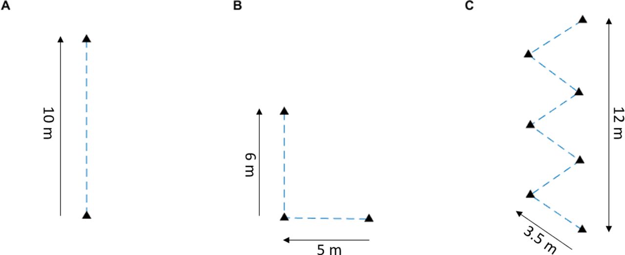
Data from a consumer-grade standalone GNSS (OptimEye S5, Catapult Sports, Melbourne, Australia) that is typically applied in team sports were collected and compared with two different reference systems: a high-end dGNSS and a tape measure. The study was conducted outdoors (59°58'01.8"N, 10°43'37.8"E) on a level sports field in open-sky conditions with no obstructions that could block or interfere with GNSS signals. The average horizontal dilution of precision was 0.63±0.08, and the average number of satellites was 16.8±0.9, measured by the consumer-grade standalone GNSS during the trials. Participants completed three courses (figure 1): course 1—Straight line sprinting and deceleration to stop (SLC); course 2—straight line sprinting, change of direction (CoD) and then deceleration to stop; and course 3—zigzag course with multiple changes of direction (mCoD). The start, end and turning points in each course were marked with cones. Participants were instructed to follow a straight path between the cones and stop exactly at the final cone, and to give maximal effort to complete the courses in the shortest time possible. Two participants executed six trials on each course, while one participant executed three trials on each course.

Schematic overview of the different courses used in this study: (A) straight line course, (B) change of direction course, (C) multiple changes of direction course.
The standalone GNSS (OptimEye S5, Firmware V.7.18) has a 10 Hz GNSS (internal GNSS antenna) and an inertial measurement unit in a casing with dimensions 96×52×13 mm, with a mass of approximately 67 g. In the current study the device was placed in a backpack (figure 2). The device was oriented in an erect position and was located on the midline between the shoulder blades.
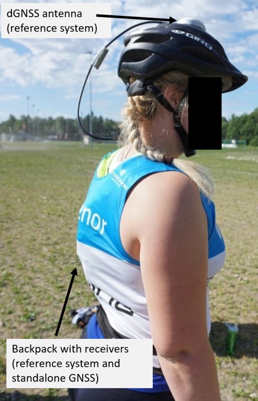
Positioning of the two GNSS systems on participants. The dGNSS reference system antenna was mounted on a helmet and coupled to the receiver in the backpack (hidden under start bib). The standalone GNSS receiver was also placed in the backpack. dGNSS, differential GNSS; GNSS, global navigation satellite system.
The dGNSS reference system consisted of a differential multifrequency and multi-GNSS receiver. The base station consisted of a GNSS antenna (Grant-G3T, Javad, San Jose, California, USA) and a receiver (Alpha-G3T, Javad) and was placed <50 m from the location where the three tasks were executed to allow short baseline differential solution calculations. The base station of the reference system was positioned in a global reference frame using data from the Norwegian Mapping Authority for postprocessing use with the precise ephemerides data and a baseline of 3 km to the closest GNSS station using geodetic postprocessing software (Justin, Javad GNSS). The participants carried a GNSS rover with an antenna (160 g, G5Ant-2AT1, Antcom, Torrance, California, USA) and a GNSS receiver (430 g, Alpha-G3T, Javad) during the data collection (figure 2). The sampling frequency was set to 20 Hz and downsampled by removing every second measurement to 10 Hz, to match the frequency of the standalone GNSS. For the dGNSS reference system, instantaneous position solutions were calculated using data from the local dGNSS base station and the dGNSS rover carried by the athlete. From these data, kinematic carrier phase double difference solutions using L1 and L2, GPS and GLONASS (the Russian GNSS) GNSS data were calculated using geodetic postprocessing software (Justin, Javad GNSS) in kinematic mode.3 The dGNSS has previously been shown to have an accuracy of ≈5 cm in highly dynamic applications.3 Both dGNSS systems and the standalone GNSS were switched on 30 min prior to the measurements to ensure ephemerides download and enough time to establish stable GNSS solutions.
In addition to the three courses, a static position accuracy test was done to compare static and dynamic (measurements in the three courses) position accuracy. Two standalone GNSS were mounted 1.5 m above ground on a tripod and put in an upright position ensuring a similar GNSS antenna orientation to that which would occur if it was mounted on an athlete. To ensure similar GNSS measurement conditions between the static and dynamic GNSS applications the static position data were collected for 15 min during the same time period as the dynamic tests were conducted. To assess the accuracy of the static standalone GNSS, the true global position of the static standalone GNSS device was measured using the same geodetic high-end dGNSS receiver, with correction data from the Norwegian Mapping Authority, and the same postprocessing method as for the local base station, as described above.
Data analysis
Horizontal plane position data (X and Y coordinates) were extracted from both the standalone GNSS and the dGNSS reference system using their respective software (OptimEye S5: Catapult Sprint, software V.5.1.7; dGNSS reference system: Justin (Javad)). All further processing and analysis were conducted in MATLAB V.R2021a (MathWorks, Natick, Massachusetts, USA). All GNSS data were transformed from WGS84 to UTM32N coordinates using ‘Geodetic Toolbox’,18 and all calculations were conducted in UTM32N. Reference system data were handled as suggested in previous research with a weighted spline interpolation.2 Position data from the standalone GNSS were recorded both raw and filtered with a second-order Butterworth filter (forward and backward) with a cut-off frequency of 4 Hz. This made it possible to assess the raw data and the impact of filtering, as filtering is commonly done in validation studies.
From the dynamic GNSS position-time measurements of the standalone GNSS and the dGNSS reference system, the following criterion measures were calculated: distance travelled, mean speed, instantaneous speed and instantaneous dynamic position. Distance travelled per trial was calculated as the sum of the Euclidean distances between consecutive horizontal plane positions along the trajectory, excluding the vertical error, as this is commonplace in team sports. Instantaneous speed in the horizontal plane (hereafter called speed) was calculated from horizontal plane position data using a four-point finite central difference formula.19 Speed was filtered with a fourth-order Butterworth filter in a forward and backward direction with a cut-off frequency of 2.5 Hz for both the standalone GNSS and the dGNSS reference system. Mean speed was calculated over the length of each trial.
The standalone GNSS and the dGNSS reference system data were time synchronised using cross-correlation of speed data in two steps: (1) position data in the horizontal plane (X and Y coordinates) were time differentiated to obtain horizontal plane speed for both the Catapult S5 and the reference system; (2) standalone GNSS and dGNSS reference system data were time synchronised using cross-correlation20 of horizontal plane speed data. After time synchronisation, data were trimmed to reflect only the time athletes were performing the trials by using a speed threshold of 0.5 m/s (determined from the standalone GNSS) to identify the start and end of trials. For the trials to be included in the data analysis, the dGNSS reference system had to have fixed ambiguities in the differential solution3 for the entire trial length. The numbers of included trials were 11 (SLC), 14 (CoD) and 11 (mCoD).
To assess position accuracy, instantaneous position differences between the standalone GNSS and the reference system were calculated for both the dynamic and static measurements. In addition, instantaneous position of the static standalone GNSS was compared with the mean position over the trial duration for the same standalone GNSS. Accuracy of distance travelled was calculated as the difference in the sum of the Euclidean distances between each position along the trajectory from start to finish. The error distributions for static and dynamic positions were visualised in a histogram, displaying the percentage distribution in each bin. Differences in distance were calculated as mean±SD. To assess the effect of the time window over which speed was averaged, the mean speed was calculated over various lengths of time windows, ranging from one point up to the entire duration of the respective trial.
Results
Position
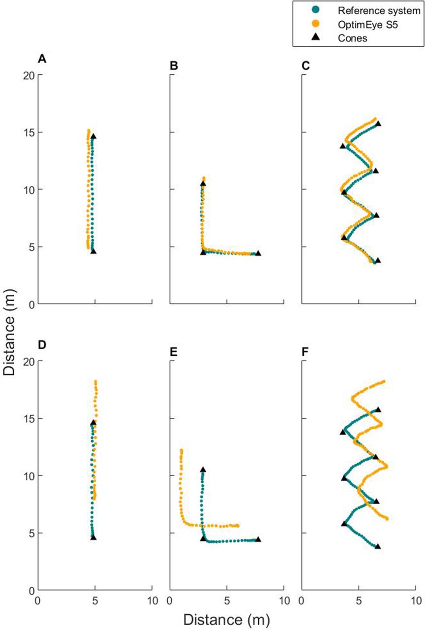
Mean errors in raw dynamic position for the standalone GNSS compared with the dGNSS reference system were 1.62±0.84 m, 1.57±0.99 m and 1.46±0.67 m for SL, CoD and mCoD, respectively. Position data from the standalone GNSS and the dGNSS reference system are depicted in figure 3. The mean error in the dynamic position (1.53±0.81 m) was larger than that in the static position (1.10±0.60 m; figure 4).

Examples of the three drills: (A, D) straight line course; (B, E) change of direction course; (C, F) multiple changes of direction course. The top row (A, B, C) exemplifies situations where the global position for the standalone global navigation satellite system (GNSS) is close to the differential GNSS (dGNSS) reference system, and the bottom row (D, E, F) shows situations where the global position of the OptimEye S5 is further away from the dGNSS reference system.
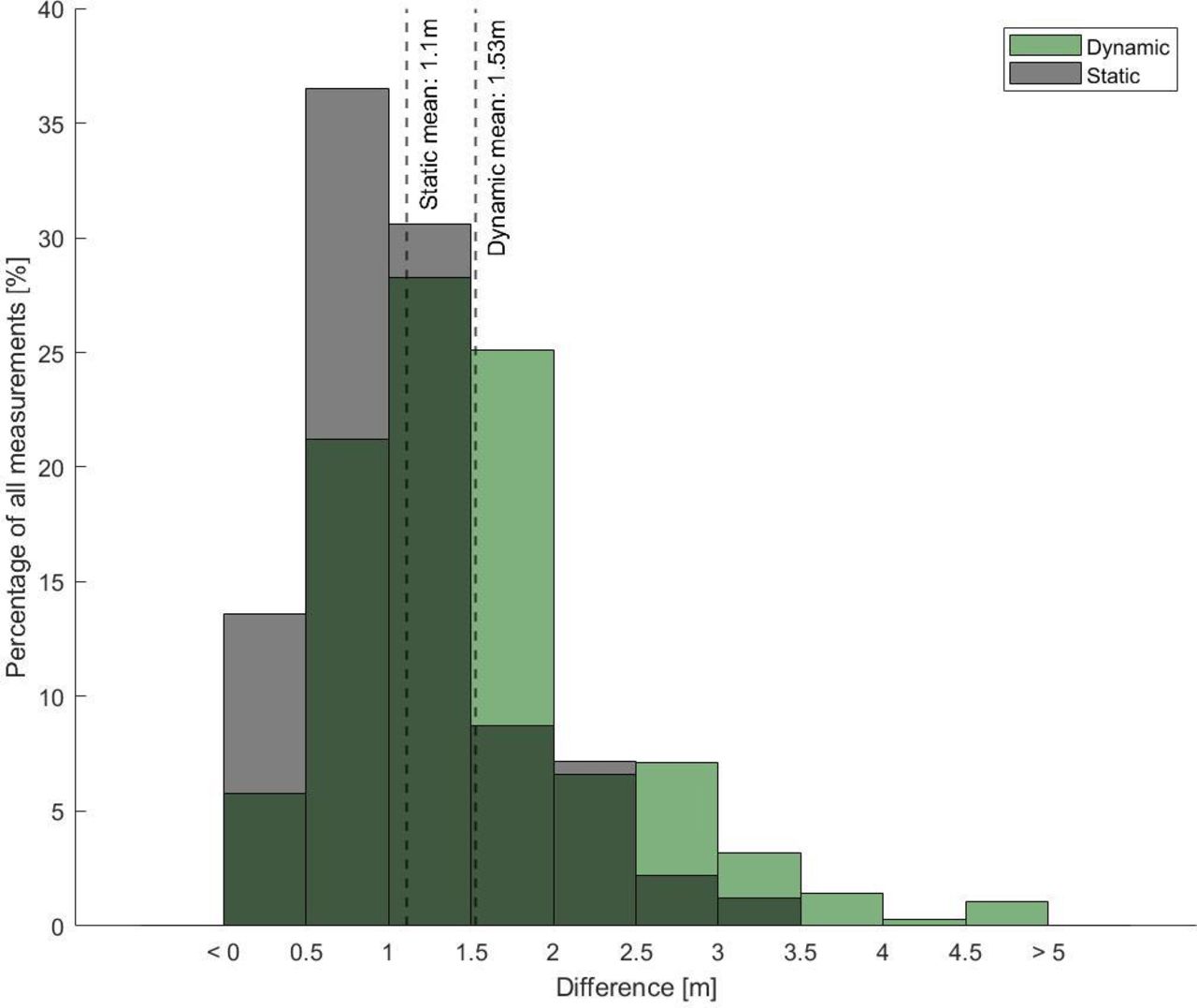
Histograms for the position error for static (grey) and dynamic (green) applications.
For the static position, the maximal error of the standalone GNSS was 1.72 and 3.20 m from the dGNSS reference system. The maximal error of the standalone GNSS from the mean standalone GNSS position was 1.59 and 1.97 m (figure 5). The total distance measured by the standalone GNSS in the static condition was 20.66 m (figure 5A) and 29.05 m (figure 5B).

Spatial distribution from two OptimEye S5 receivers. Instantaneous position, mean position of the standalone global navigation satellite system (GNSS) and the reference system position are placed in a local coordinate system to show the magnitude of the errors. (A) and (B) are the two different OptimEye S5 devices used. X-axis, easting; Y-axis, northing.
Distance
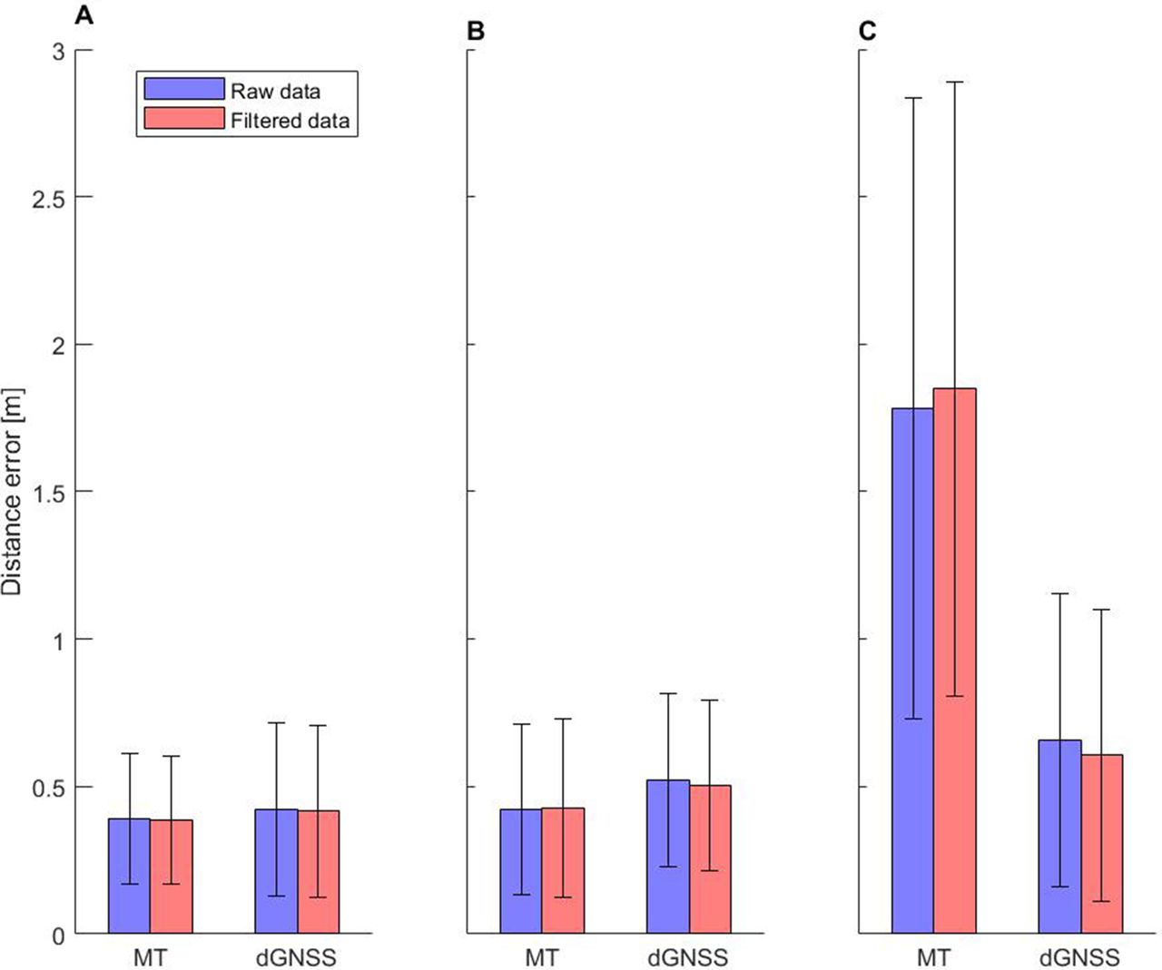
The distance measured by dGNSS varied from 6% longer to 17% shorter compared with the predefined course that was measured by tape measure (table 1). None of the distances measured with the dGNSS systems in the CoD and mCoD courses during the trials were greater than the distances of the predefined courses measured with the tape measure. When comparing errors in the standalone GNSS to the two reference systems, the differences in errors were larger in the mCoD course compared with the other courses (figure 6).
Distance measured with the measure tape and dGNSS reference system

Error in distance from measure tape (MT) and dGNSS reference system for the courses: (A) straight line course, (B) change of direction course, (C) multiple changes of direction course. dGNSS, differential global navigation satellite system.
Speed
The distribution of errors in mean speed and instantaneous speed differed both in mean (absolute error 0.10 vs 0.28 m) and in range (figure 7). Large reduction in error was found when longer time windows were used for mean speed calculations (figure 8).

Histograms for instantaneous speed (top row) and mean speed (bottom row) errors with both raw and filtered data for the courses: (A, D) straight line course; (B, E) change of direction course; (C, F) multiple changes of direction course.

Cumulative mean speed error measurements for the multiple changes of direction (mCoD) task, normalised as percentage of the total epochs in each trial.
Discussion
The main finding of this study was that the choice of criterion measure and reference system has a substantial impact on the errors in position, distance and speed and is hence critical for the veracity of validation studies.
Position
The position error of tracking systems is typically investigated in two different ways: (1) with static measurements21 22 or (2) with dynamic measurements.11 23 For the assessment of static position, two methods were used as a reference: either the use of a known point in a global reference frame (eg, using a reference system to measure the true position)22 24 25 or use of the time-averaged position from the same measurement system being validated.21 The latter approach will not yield information about the accuracy of the tracking system but is instead a measure of precision (variability around the mean). This is comparable to investigations of interdevice reliability of tracking systems, where typically the data from several units mounted on the same athlete are compared with each other to assess whether different units of the same type provide similar results. Such testing should not be confused with system accuracy assessment. Therefore, accuracy of position (both static and dynamic) must be assessed against a global reference position. In addition, position accuracy assessment should be conducted for a period of at least several hours, especially when assessing standalone GNSS (such as OptimEye S5), since the position error of such devices drifts substantially over time and a long measurement time is needed to cancel out coincidental results. Examples of such global drift over time and drift from trial to trial can be seen in figures 3 and 5, and in the study by Jølstad et al.7
Our data showed that dynamic position measurements had both a larger mean error and a larger range in errors compared with errors from static position testing. This implies that static position accuracy cannot be used as a proxy for dynamic position accuracy of tracking systems. Hence, in order to not mislead the users of position tracking devices, position error should be validated against a global reference system and frame that allow instantaneous position tracking in a dynamic application. Dynamic position is usually not included in validation studies for team sport tracking devices.15 However, its inclusion would provide reliable assessment of validity of a system across time periods, when software and firmware are updated by the manufacturer, which may change the parameter calculation methods such as position measurement, and the calculation of propagation parameters (eg, distance and speed). Future studies should also validate dynamic position to include spatial-tactical behaviour analysis. Additional guidance for instantaneous position validation using dGNSS has previously been provided by Specht and Szot.26
Distance
Our data show differences between the tape measure and dGNSS reference systems for the three courses, with larger differences in the courses incorporating CoD (table 1). As previously mentioned, there are deviations in human locomotion from predefined straight line paths. Using tape measure as a reference precludes measurements of the deviations from the straight line, which might be an important factor for the differences in this study. Hence, the choice of tape measure over dGNSS or another instantaneous position tracking device as a reference system can affect the outcome of distance validation, leading to an underestimation or overestimation of the accuracy of a tracking system, depending on the sport task. Since team sports include a large number of CoD, it is therefore recommended to use a position tracking device to validate distance, instead of a tape measure.
Speed
Reference systems such as tape measures and timing gates only allow for validation of mean speed. However, mean speed over longer time periods is not a good representation of intensity in team sports, since an athlete’s speed fluctuates substantially.27 In comparison, tracking of instantaneous speed allows speed to be presented as a distribution of time or distance covered in different speed zones,1 which provides better insight into the speed characteristics of a match or training session, and is now commonly used in team sports. The use of mean speed instead of instantaneous speed to represent team sport intensity is therefore a critical shortcoming for sport analysis and validation studies. Figure 7 illustrates how the use of mean speed as a measure of speed accuracy is misleading, since the mean error drops substantially when only a few epochs are averaged. Hence, in system validity assessments, mean speed cannot be used as a proxy for instantaneous speed, even when averaged over short time periods. Reference systems should therefore be able to measure instantaneous speed and be properly time synchronised with the system being assessed. The use of such reference systems is already common practice in other sports domains, such as winter sports.2–8 26 28 29
Methodological considerations
This study used dGNSS and a tape measure as reference systems to illustrate the consequences of the choice of criterion measure and reference system on validation outcomes. Other reference systems such as timing gates, radar guns, trundle wheels and video-based and infrared camera-based motion capture systems should also be assessed to establish a more complete overview of the differences between reference systems. The main goal of this study, however, was to highlight the importance of the appropriate choice of reference system for use in validation studies.
In our study, the dGNSS reference system antenna was placed on the head while the standalone GNSS antenna was placed between shoulder blades (figure 1). This causes a deviation in the horizontal plane position in the scale of a few decimetres, which could introduce some error. However, this error is small compared with the expected position error of the standalone GNSS used in this study (scale of metres). The present set-up did not allow us correction of the offset between the two systems. However, this is an aspect that should be taken into consideration when conducting validation studies.
The error characteristics (accuracy and precision) of position, distance and speed will be different for measurement systems other than the ones used in this study. For example, drift of position error over time will be different for an LPS. The essence of this study is not the exact values for the specific GNSS system validated in this study, but the principles of validity assessment that will also apply to other measurement systems.
Filtering of data can play a large role in parameter calculation30 and caution is therefore indicated when using an unknown filtering technique (eg, at the manufacturer’s discretion) in validation studies. We have therefore displayed both the raw and filtered data to show the typical effect of filtering. The cut-off frequencies used in this study can be considered conservative, and were chosen since previous studies have shown that liberal filtering can influence parameter calculations to a large extent.31 Future validation studies should also investigate the effect of different filters on parameter accuracy in typical team sport applications.
Perspectives
This study has shown that the choice of reference system to validate tracking systems can substantially affect the outcome of validation studies. The reference systems should therefore be a true gold standard to assess the criterion measure in question. The use of tape measures to validate distance travelled along a trajectory of the participant is not recommended since this method does not account for the deviations an athlete makes from the straight line path between the marked positions on the course.
To assess standalone GNSS, as in this study, the reference should typically be a high-end dGNSS or a video-based or infrared camera-based motion capture system, which allows instantaneous and sufficiently accurate quantification of an athlete’s path. Use of an appropriate reference system may have a wider application, be more appropriate to assess team sport-specific parameters and keep track of changes in parameter calculation across firmware/software versions, which might change over time.
Conclusion
This study provides novel insight into the impact of the validation methodology for position tracking systems on the validity outcomes of such studies. The choice of the criterion measure and reference system substantially affected the outcome of accuracy for position, distance and speed. Static position and mean speed cannot be used as proxies for dynamic position and instantaneous speed, respectively. The outcomes of validation studies should always be interpreted in the light of the validity of the reference system that was used in the respective validation studies. Caution is warranted when comparing validation studies with different reference systems.
Data availability statement
Data are available upon reasonable request.
Ethics statements
Patient consent for publication
Ethics approval
This study involves human participants but because of the low risk and impact on participants, and because the study does not research any health-related outcomes, Norwegian law does not require the regional ethics committee to take our ethics application. The study is therefore not viewed or approved by an ethics committee. The study did adhere to the Helsinki Declaration. The study was not consideredby our institution to be harmful or in breach of any ethical standards, but the project has not gone through a standardised institutional board process (as this was not established at our institution at the time of data collection in this study). Participants gave informed consent to participate in the study before taking part.
Acknowledgments
The authors would like to thank the participants involved in this study.
Footnotes
Twitter @livesl
Contributors MG and LSL conceptualised the study and carried out the data collection. PAHJ was in charge of the data analysis. All authors were involved in interpretation of the results. LSL wrote the draft for the manuscript. All authors have been involved in critically revieweing the manuscript and approved the final submitted version. LSL is the guarantor of the work, meaning that she accepts full responsibility for the finished work and/or the conduct of the study, had access to the data, and controlled the decision to publish.
Funding The authors have not declared a specific grant for this research from any funding agency in the public, commercial or not-for-profit sectors.
Competing interests None declared.
Patient and public involvement Patients and/or the public were not involved in the design, or conduct, or reporting, or dissemination plans of this research.
Provenance and peer review Not commissioned; externally peer reviewed.